
The team behind the Heritage Gazetteer of Cyprus were in Nicosia last week, presenting a near-final form of the project to an audience of experts in Cypriot history and archaeology. The resource the project has been tasked by the A. G. Leventis Foundation to produce is very nearly complete, and will be launched to the world in January 2015.
The HGC has always been about the names of places, and how these names change over time. As I have blogged about previously, and as we outlined in our presentation to the International Cartographic Association’s Digital Approaches workshop in Budapest in September, this name-driven approach, which is based on three layers of data – modern toponyms, ‘Historical Units’ and ‘Archaeological Entities’ represents the limits of the current project. However what it cannot do raises important intellectual questions about how digital representations of place are organized and presented online. The aim of this post is to capture some of these questions, particularly with regard to our ‘Historic Unit’ data layer.
To recap the definitions: a modern toponym is, quite simply, the official name currently in use, and the only data sources for this are official ones – currently in the form of the Complete Gazetteer of Cyprus (Konstantinides and Chrisotodolou 1987). In our presentation last Thursday, we reiterated our definition of an HU as:
“Entities of substantial geographical extent and significance, such as towns, archaeological sites and the extents of kingdoms”
And AEs as:
“A discrete feature, with a distinct spatial footprint, formed in a definable period”
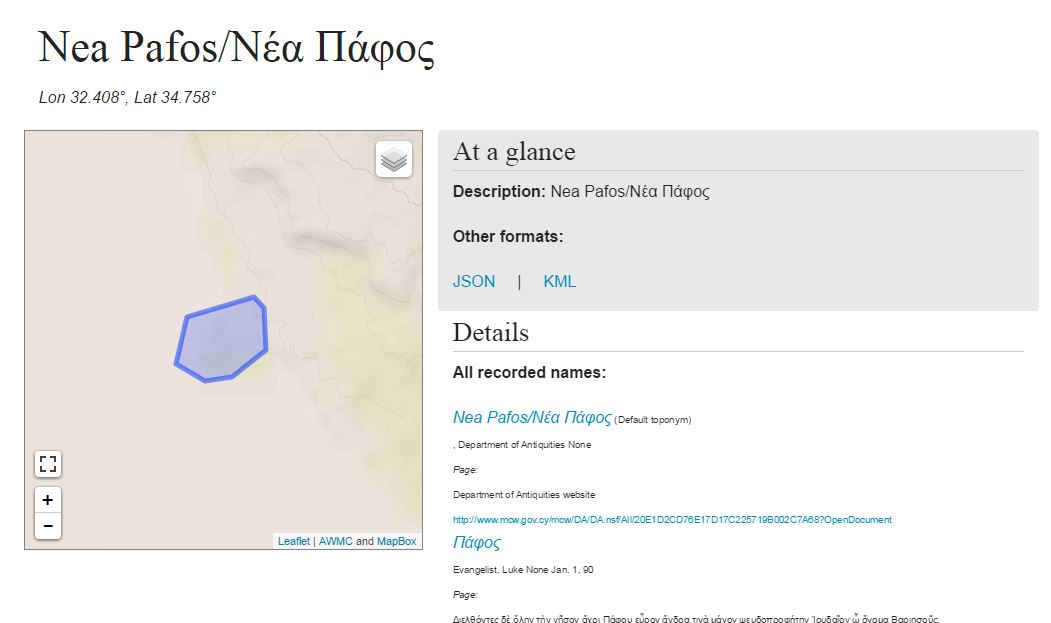
This definition of an AE is relatively clear. Most importantly, the reference to a ‘distinct spatial footprint’ means that it is related to mappable feature, which is extrinsic to any definition in the HGC data structure. However, a colleague at the meeting expressed the general view when he described HUs as being “the most interesting aspect, but also the most problematic”. Currently, they are defined on the map as a polygon, drawn by the user when they create the HU record. In some cases, a polygon can be defined relatively straightforwardly. For example the Venetian walls of Nicosia form a discrete spatial footprint, that can be traced using the HGC’s geocoding tool. But in most cases, this requires a subjective judgement, and thus a subjective representation, that is arguably inimical to the positivist interpretation which any robust database requires; and imposes exactly the kind of Cartesian absolutism that I and others have railed against in several recent and forthcoming publications. Further, creating an HU in this way can lead to our grouping data points that are actually very different in nature. Sometimes an HU will equate to a modern toponym (such as Marchello, in Nea Paphos), and sometimes it does not. Hellenistic kingdom of Paphos is another example of a composite; whereas medieval/Venetian Nicosia is a defined location. As another colleague commented on the project recently:
“The concept of Historical Units is something that I think needs some additional definition. I understand that other standards have the same fuzzy things, but poorly defined things add increasing difficulty as the dataset grows. My reading … is that you mean geographical feature which is uncomfortably close to Archaeological Entity. Have you considered just calling them ‘historical features’ and having a containment / recursive relationship?”
As we take the HGC forward therefore, we propose to modify this artificial footprinting mechanism, so that an HU is rather represented by a set of thematically, but not necessarily geographically, conjoined AEs.
This speaks to a much more fundamental problem of how archaeological data – bearing in mind that the HGC is about names, and is thus more a creature of history than of archaeology – is recorded. Much rhetoric of the semantic web in the discipline, at least in its earlier phases, focused on the need to link archaeological datasets ‘organically’, where data produced by one site can be linked and contextualized with that from another, without the excavation teams of either having to adopt a priori methods or procedures for data production. This may hold true to an extent, but our experience with HUs especially shows that when combining such data, some kind ofa posteriori aggregation process must be undergone. Otherwise, quite simply, one adds little to the data by linking it. In our current model, this is imposed by the user doing the aggregating; but the subjectivity this introduces is fraught with difficulties. Therefore, our next steps will be to develop our categorising and attributing capabilities for AEs, and begin aggregating into HUs on that basis. They will therefore be grown from the ground up in a way that is guided by the HGC data structure, rather than imposed from the user downwards.

Reblogged this on Erik Champion and commented:
Interesting. I wonder if Historical Units for 3D digital models could be a spatial envelope (or more than one)..
Hi Erik – no reason why not. The problem with them is their subjectivity. So the key thing is how the process of ‘enveloping’ is achieved. But in principle it would be really interesting to see how the approach could be applied to 3D models as well as 2D maps.
Stuart, nice to see you recognise both the potential and the limitations of the semantic web and are taking a pragmatic approach. i am tired of the purely academic marketing hype and it’s great to see someone applying it to real problems. All the best,
Katie
Hi Katie – thanks for your kind words. Once we thought TEI/XML would solve all our problems, in fact it solved some of our problems (albeit in some new and interesting ways) and I feel we are the same expectations point with LOD. It’s great for describing the data world, but that’s not always the same as the real world…
Talking of the real world, I have been checking out your work for Stanford in their Spatial History group and the cross-disciplinary nature of it really appeals to me, especially the GIS focus. I would love to study there one day (currently working in IT, whilst studying history masters at ANU but also an ex-landscape architect). Anyway, got to get through the Masters first but great to find areas of future interest…